HOPEWELL ROCKS PROVINCIAL PARK
BEZIENSWAARDIGHEDEN / HIGHLIGHTS
.jpg)
Bezienswaardigheden / tips Hopewell Rocks Provincial Park 2026:
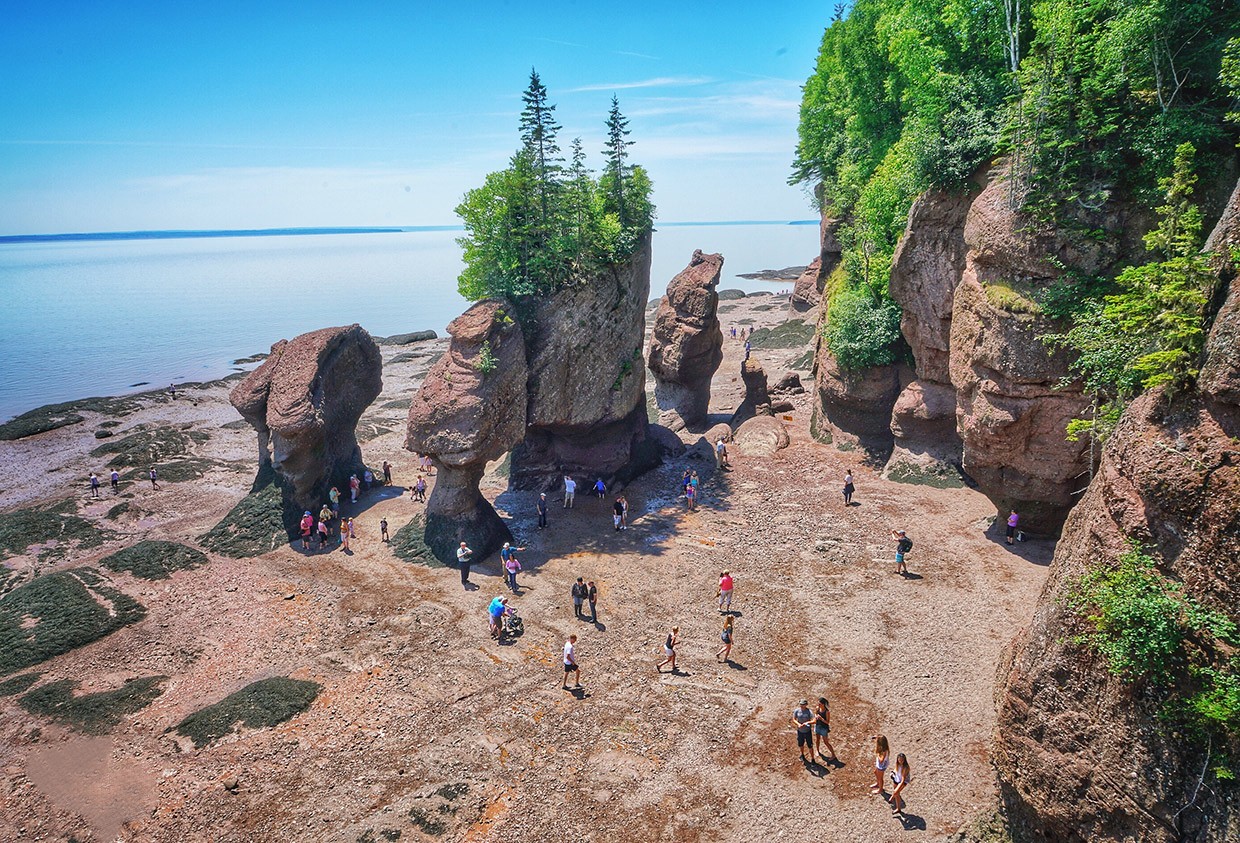
1) Hopewell Rocks Provincial Park: Hopewell Rocks Provincial Park ligt aan de Bay of Fundy. Het park is wereldberoemd vanwege de hoogste getijden ter wereld. Het water kan hier tot wel 10 tot 16 meter stijgen en dalen. Door deze extreme getijden zijn in miljoenen jaren tijd bijzondere rotsformaties ontstaan, vooral de bekende "flowerpot Rocks" hoge stenen pilaren met bomen bovenop. Bij laagwater kun je over de oceaanbodem lopen en de rotsen van dichtbij bekijken. Bij hoogwater staan dezelfde rotsen volledig in zee en kun je er langs kajakken. Hopewell Rocks is uniek omdat je op één plek twee totaal verschillende landschappen kunt zien, afhankelijk van het getij. Daarom is het een van de bekendste natuurattracties van oostelijk Canada. Per jaar bezoeken ongeveer 280.000 toeristen Hopewell Rocks Provincial Park, aanzienlijk minder dan de favoriete Nationale Parken aan de westkust. Dit heeft zijn voordelen want je wordt niet overlopen door het toerisme. Bij Hopewell Rocks Provincial Park moet je entree betalen, de toegang geldt meestal voor twee opeenvolgende dagen, zodat je zowel laag als hoogwater kunt beleven. Een ticket voor een volwassenen kost CAD 18,15.
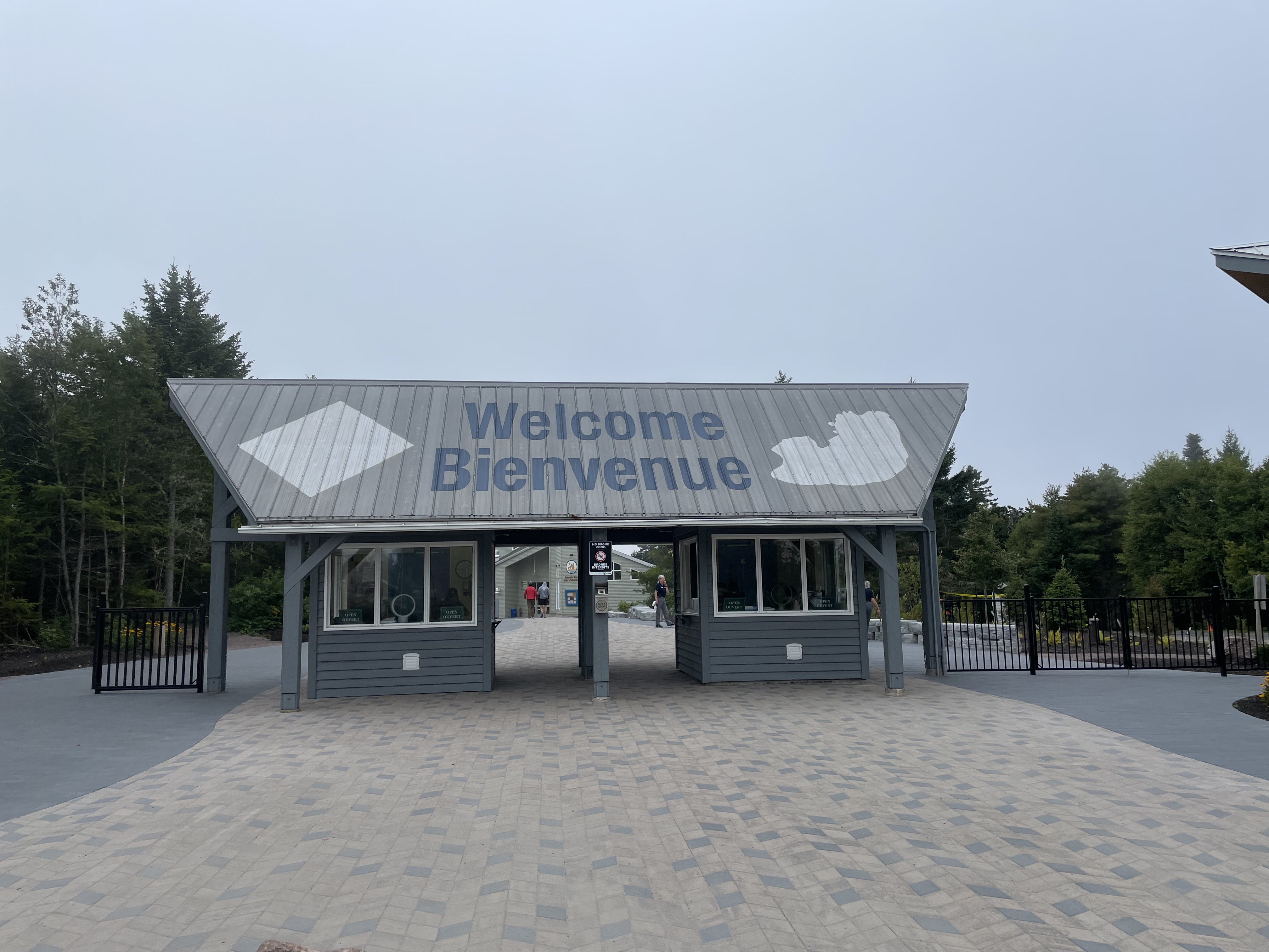
2) Interpretive Centre: Het Interpretive Centre is een bezoekers en informatiecentrum waar je met interactieve en educatieve presentaties leert over de gigantische getijden van de Bay of Fundy, hoe de Flowerpot rotsen gevormd zijn door erosie en de geologie en biodiversiteit van het gebied. Ook kun je hier geluiden van walvissen uit de Bay of Fundy beluisteren en informatie vinden over dieren, planten en getijdenprocessen. In het Interpretive Centre is ook een giftshop en de Low Tide Café waar je iets kunt eten en drinken. Het is een goede startplek voor je parkbezoek vooral om de getijden en wandelopties te bekijken.
3) Flowerpot Rocks: Op ongeveer 1 km (enkele reis) lopen vanaf het bezoekerscentrum kun je de Ocean Floor Access Trail volgen naar de Flowerpot Rocks. Vanaf een platform loopt een steile ijzeren trap langs de loodrechte kust omlaag naar het strand waar de Flowerpot Rocks staan. De Flowerpot rocks zijn vrijstaande rotsformaties die door erosie zijn afgescheiden van de kust. Hun naam komt van de bomen en struiken die bovenop de rotsen staan en eruitzien alsof ze in een bloempot staan. De Flowerpot rocks zijn het absolute icoon van Hopewell Rocks.
4) Diamond Rock Lookout: Tijdens de wandeling vanaf het Interpretive Centre richting de Flowerpot rocks kom je halverwege de wandeling bij het uitzichtpunt Diamond Rock. Dit is een bovenliggend pad en platform die je panoramische vergezichten geven zonder dat je naar de oceaanbodem hoeft af te dalen. Vanaf Diamond Lookout heb je uitzicht op een rotsformatie die bekend staat als Diamond Rock, een van de vele herkenbare flowerpot rocks (zeestapels) in het park.
5) Daniels Flats Lookout Trail: De Daniels Flats Lookout Trail is een korte en makkelijke wandeling vanaf het Interpretive Centre en brengt je naar de uitkijkpunten over de zeer brede moddervlakten van Daniels Flats, een immense geul van de Bay of Fundy die bij laag tij honderden meters breed droogvalt.
6) Demoiselle Beach Trail & Demoiselle Lookout: Vanaf het Interpretive Centre loopt een makkelijk pad van 0,7 km (enkele reis) door een bosgebied en brengt je naar Demoiselle Lookout en Demoiselle Beach. Bij de Lookout heb je een uitstekend panoramisch uitzicht over de mudflats en is spectaculair bij laag en hoog water, ideaal om het getijdenverschil te ervaren. Ook kun je hier over de oceaanbodum wandelen en de rotsen van dichtbij bekijken en door kleine inhammen lopen. Het is hier rustiger en minder druk maar let wel goed op het getij.
7) Big Cove Lookout Trail: De Big Cove Lookout Trail is een korte zijroute vanaf de hoofdtrail naar de oceaanbodem. De trail is makkelijk en loopt langs een bospad en is ongeveer 1,6 km lang (retour). Het uitkijkpunt boven Big Cove heeft een panoramische uitzicht over de moddervlakten, de zee en rotsformaties. Dit gedeelte is rustiger dan de centrale Flowerpot Rocks, ideaal voor fotografie, vogelspotting en natuurgenot.
8) Getijden: De getijden komen ongeveer twee keer per dag op en gaan weer neer. Een getijcyclus (van laag naar hoog en weer terug) duurt ongeveer 12 uur. Gemiddeld zit er 6 uur en 13 minuten tussen laag water en hoog water. De waterstand kan daarbij tussen de 10 en 16 meter hoog worden. Zorg dus dat je de getijdenkaart van het Interpretive Centre bij je hebt als je een strandwandeling gaat maken en let op wanneer het water begint te stijgen, want de vloed komt hier uitermate snel opzetten, soms wel tot 16 meter hoog.
9) Beste Reistijd: Mid-mei tot midden oktober is de beste periode om Hopewell Rocks te bezoeken. Maar in de zomer, vooral in juli en augustus, is het hier vaak erg druk en kun je het prachtige landschap beter 's ochtends vroeg bewonderen.

1) Hopewell Rocks Provincial Park: Hopewell Rocks Provincial Park is located on the Bay of Fundy.The park is world-famous for its highest tides, which can rise and fall as high as 10 to 16 meters. These extreme tides have created unique rock formations over millions of years, particularly the famous "flowerpot rocks"—tall stone pillars topped with trees. At low tide, you can walk on the ocean floor and view the rocks up close. At high tide, these same rocks are completely immersed in the sea, and you can kayak past them. Hopewell Rocks is unique because you can see two completely different landscapes in one place, depending on the tide. This makes it one of eastern Canada's most famous natural attractions. About 280,000 tourists visit Hopewell Rocks Provincial Park annually, significantly fewer than the popular national parks on the west coast. This has its advantages because you are not overrun by tourism. Hopewell Rocks Provincial Park has an entrance fee, which is usually valid for two consecutive days, allowing you to experience both low and high tide. An adult ticket costs CAD 18.15.
2) Interpretive Centre: The Interpretive Centre is a visitor and information center where you can learn about the Bay of Fundy's massive tides, how the Flowerpot Rocks were formed by erosion, and the area's geology and biodiversity through interactive and educational presentations. You can also listen to whale sounds from the Bay of Fundy and find information about animals, plants and tidal processes. The Interpretive Centre also features a gift shop and the Low Tide Café, where you can enjoy food and drinks. It's a good starting point for your park visit, especially for exploring the tides and hiking options.
3) Flowerpot Rocks: About a o,6 mile (1 km one way) walk from the visitor center, you can follow the Ocean Floor Access Trail to the Flowerpot Rocks. From a platform, a steep iron staircase descends along the sheer coastline to the beach where the Flowerpot Rocks stand. The Flowerpot Rocks are freestanding rock formations that have been separated from the coast by erosion. Their name comes from the trees and shrubs that grow on top of the rocks, which look like they're in a flowerpot. The Flowerpot Rocks are the absolute icon of Hopewell Rocks.
4) Diamond Rock Lookout: On the hike from the Interpretive Centre towards the Flowerpot Rocks, you'll reach the Diamond Rock Lookout halfway along the trail. This elevated path and platform offer panoramic views without having to descend to the ocean floor. From Diamond Lookout, you have a view of a rock formation known as Diamond Rock, one of the many recognizable flowerpot rocks (sea stacks) in the park.
5) Daniels Flats Lookout Trail: The Daniels Flats Lookout Trail is a short and easy walk from the Interpretive Centre and takes you to viewpoints overlooking the expansive mudflats of Daniels Flats, a vast channel of the Bay of Fundy that stretches hundreds of metres wide at low tide.
6) Demoiselle Beach Trail & Demoiselle Lookout: From the Interpretive Centre, an easy 0.4 mile (0.7 km one way) trail leads through a wooded area and takes you to Demoiselle Lookout and Demoiselle Beach. The Lookout offers excellent panoramic views of the mudflats, spectacular at both low and high tide, perfect for experiencing the tidal range. You can also walk across the ocean bed here and view the rocks up close and walk through small inlets. It's quieter and less crowded here, but be mindful of the tides.
7) Big Cove Lookout Trail: The Big Cove Lookout Trail is a short side trail from the main trailhead to the ocean floor. The trail is easy and follows a forest path and is approximately 1 mile (1.6 km round trip). The lookout above Big Cove offers panoramic views of the mudflats, the sea, and rock formations. This section is quieter than the central Flowerpot Rocks, ideal for photography, birdwatching, and nature viewing.
8) Tides: Tides rise and fall approximately twice a day. A tidal cycle (from low to high and back again) lasts about 12 hours. A tidal cycle (from low to high tide and back again) lasts about 12 hours. On average, there's a 6-hour and 13-minute interval between low and high tide. The water level can reach between 10 and 16 meters (33 and 52 feet). So make sure you take the tide chart from the Interpretive Centre with you when you go for a walk on the beach and pay attention to when the water starts to rise, because the tide comes in very quickly here, sometimes up to 16 meters high.
9) Best Time to Visit: Mid-May to mid-October is the best time to visit Hopewell Rocks. However, in the summer, especially July and August, it's often very crowded, and the stunning scenery is best appreciated early in the morning.
.jpg)
Bij binnenkomst bij de Hopewell Rocks staat het Interpretive Centre. In het Interpretive Centre, naast de belangrijkste parkeerplaats van het park, belicht een multimediale tentoonstelling de geologie van de Fundykust en de invloeden van de enorme getijdenverschillen. Er hoort ook een restaurant bij, de High Tide Café, waar je voor of na afloop van het wadlopen kunt eten en relaxen.
Upon entering Hopewell Rocks, you'll find the Interpretive Centre. In the Interpretive Centre, next to the park's main parking lot, a multimedia exhibition highlights the geology of the Fundy coast and the influence of the enormous tidal ranges. There's also a restaurant, the High Tide Café, where you can eat and relax before of after your mudflat hike.
.jpg)
.jpg)
Vanaf het Interpretive Centre kun je meerdere padden bewandelen naar de oceaanbodem. De meest bekende trail wordt meteen al aangeduid vlak bij het restaurant en loopt tot het platform en de trap richting de oceaanbodem.
From the Interpretive Centre, you can walk several trails to the ocean floor. The most well=known trail is immediately signposted near the restaurant and runs to the platform and the stairs down to the ocean floor.
.jpg)
.jpg)
Een indrukwekkend gevolg van de getijdenwerking in de Bay of Fundy zijn de Hopewell Rocks. In een tijdsbestek van duizenden jaren hebben de af en aan stromende watermassa's hier een eigenaardig landschap van holen en stenen sculpturen uit het gesteente geslepen. Het meest in het oog springen de Flowerpot Rocks, die bij eb nog het meeste weg hebben van enorme bloempotten. Bij vloed, waarbij het water gemiddeld 16 meter stijgt, steken ze enkel nog als kleine eilandjes boven het wateroppervlak uit. Hier op beide foto's eb en vloed.
An impressive result of the tidal action in the Bay of Fundy are the Hopewell Rocks. Over thousands of years, the ever-flowing waters here have carved a peculiar landscape of caves and stone sculptures out of the rock. The most striking feature is the Flowerpot Rocks, which at low tide resemble enormous flowerpots. At high tide, when the water rises an average of 50 feet (16 meters), they only protude above the water surface as small islands. Here in both photos the ebb and high tide.
.jpg)
Er is een grote metalen trap die loopt van het uitkijkplatform recht naar beneden tot aan de oceaanvloer (zie film).
There is a large metal staircase that runs from the viewing platform straight to the ocean floor (see film).
.jpg)
.jpg)
Bij eb kun je op de drooggevallen kuststrook wandelen, de uitgesleten holen en de voetstukken van de bloempotten van nabij bekijken en in de achtergebleven plassen allerlei zeedieren als zeeanemonen en mosselen ontdekken (zie film).
At low tide you can walk along the exposed coastline, take a closer look at the eroded caves and the bases of the flower pots, and discover all kinds of sea creatures such as sea anemones and mussels in the remaining pools (see film).
.jpg)
.jpg)
Het grootste deel van de bodem is zacht en modderig zand, soms vermengd met klei. Hier en daar kom je stenen, kiezels en kleine rotsfragmenten tegen, vooral rond de basis van de rotsen.
Most of the soil is soft, muddy sand, sometimes mixed with clay. Here and there you'll find stones, pebbles, and small rock fragments, especially around the bases of the cliffs.
.jpg)
.jpg)
Door de extreme getijden (tot 16 meter verschil) worden de rotsen en zeebodem zowel onderwater als boven water blootgesteld. Zeewier groeit voornamelijk op de rotsen en in de natte getijdenpoelen, waar het altijd een beetje vochtig blijft (zie film).
The extreme tides (up to 50 feet, 16 meters) expose the rocks and seabed both underwater and above water. Seaweed grows mainly on the rocks and in the wet tidal pools, where it always remains slightly moist (see film).
.jpg)
.jpg)
De rotsen zijn 20 meter hoog. Vanaf boven lijken ze al groot, maar ernaast staan op de zeebodem laat je pas echt voelen hoe enorm ze zijn (zie film).
The rocks are 65 feet (20 meters) high. From above, they already seem large, but standing next to them on the seabed truly makes you realize just how enormous they are (see film).
.jpg)
.jpg)
Bij laagtij is het er vaak verrassend stil, geen golven, alleen wind, vogels en de natte zand onder je voeten (zie film).
At low tide it is often surprisingly quiet, no waves, only wind, birds and the wet sand under your feet (see film).
.jpg)
.jpg)
.jpg)
Er zijn maar weinig plekken op aarde waar je veilig en legaal op de oceaanbodem kunt wandelen tussen zulke mooie rotsformaties (zie film).
There are few places on Earth where you can safely and legally walk on the ocean floor among such beautiful rock formations (see film).
.jpg)
.jpg)
.jpg)
Diamond Rock is genoemd naar de manier waarop het zonlicht op het oppervlak kan schitteren, wat het een diamantachtig uiterlijk kan geven vanuit bepaalde hoeken (zie film).
Diamond Rock is named for the way sunlight can sparkle on its surface, giving it a diamond-like appearance from certain angles (see film).
.jpg)
.jpg)
Het is een natuurlijk uitzichtpunt binnen het park waar bezoekers kunnen stoppen om het landschap en de omgeving te bewonderen tijdens eb en vloed.
It is a natural viewpoint within the park where visitors can stop to admire the landscape and surroundings during the high and low tides.
.jpg)
.jpg)
Les Estrans of Daniel's Flats verwijst naar één van de uitkijkpunten. Het geeft een panoramisch uitzicht over de uitgestrekte moddervlakte van Daniel's Flats, vooral indrukwekkend bij laagtij wanneer het water zich ver terugtrekt en de zeebodem blootlegt.
Les Estrans, or Daniel's Flats, refers to one of the viewpoints. It offers a panoramic view of the vast mudflats of Daniel's Flats, especially impressive at low tide when the water recedes far, exposing the seabed.
.jpg)
Hier op de foto ook een prachtig uitzicht op Les Estrans of Daniel's Flats tijdens vloed en het mooie weer (zie film).
Here in the photo also a beautiful view of Les Estrans or Daniel's Flats during high tide and the nice weather (see film).
.jpg)
.jpg)
Demoiselles Beach is een deel van het Hopewell Rocks gebied waar je tijdens laagwater ook over de oceaanbodem kunt lopen.
Demoiselles Beach is part of the Hopewell Rocks area where you can also walk on the ocean floor during low tide.
.jpg)
.jpg)
.jpg)
Op het Demoiselles beach zijn de rotsen smal, hoog en elegant gevormd en daarom is het strand genoemd naar de rotsformaties die lijken op elegante jonge vrouwen, vandaar de naam in het Frans.
At Demoiselles beach, the rocks are narrow, high and elegantly shaped, which is why the beach is named after the rock formations that resemble elegant young women, hence the name in French.
@MK